DDC Blog

What's Happening at Discovery Diving

Get all the latest info from our Instructors and Staff on our SCUBA Classes, Charters, Equipment and Special Events.

  • Home
    Home This is where you can find all the blog posts throughout the site.
  • Categories
    Categories Displays a list of categories from this blog.
  • Tags
    Tags Displays a list of tags that have been used in the blog.
  • Bloggers
    Bloggers Search for your favorite blogger from this site.
  • Team Blogs
    Team Blogs Find your favorite team blogs here.
  • Login
    Login Login form

Welcome to Odyssey's Virtual Museum

Odyssey is the world leader in deep-ocean shipwreck exploration, searching the globe's vast oceans for sunken ships with intriguing stories, extraordinary treasure and precious artifacts spanning centuries of maritime travel. Our important discoveries also uncover priceless new knowledge and history from the depths. As we recover these shipwreck treasures once believed lost forever, we also resurrect lifetimes long forgotten, offering a rare and fascinating window into historic events that would otherwise remain obscure.

Odyssey's expert team of researchers, scientists, technicians and archaeologists search the oceans of the world, recovering shipwreck treasures once thought lost forever. We love to share these amazing discoveries and over two million people have enjoyed viewing artifacts from our permanent collection in person at museums and science centers around the world. Now, we’re bringing our collection right to your computer.

Odyssey’s Virtual Museum is a work in progress, and new artifacts from our various shipwreck projects will be added on a regular basis. The multitude of artifacts in Odyssey's Permanent Collection, spanning more than 2000 years of maritime history, continues to grow as new shipwrecks are discovered and investigated.

http://odysseysvirtualmuseum.com/ 

Hits: 1858
0

Posted by on in Wrecks

 Project Overview

The SS Republic®* was a Civil War-era sidewheel steamship that sank in 1865 while carrying a large cargo of silver and gold coins and a stunning variety of everyday wares essential to life in mid-19th century America. It was discovered by Odyssey Marine Exploration in 2003.

En route from New York to New Orleans with passengers and commercial cargo, the SS Republic was lost in a violent hurricane on October 25, 1865. The passengers and crew escaped from the sinking ship, yet a fortune in coins and much needed cargo to help rebuild New Orleans' post-Civil War economy sank to the bottom of the Atlantic seabed 1,700 feet (518 meters) deep. Nearly 140 years later, Odyssey discovered the shipwreck of the Republic approximately 100 miles off the Georgia coast. The archaeological excavation conducted during the 2003-2004 excavation seasons was accomplished entirely through the use of advanced robotics and cutting-edge technologies and was the first of its kind ever performed at such depths. 

Over 51,000 U.S. gold and silver coins were recovered from the Republic wreck site, as well as over 14,000 artifacts - a fascinating assortment of 19th century goods in use during the Civil War years. In addition to the wealth of knowledge gained from the Republic shipwreck project, the success of the archaeological excavation has set a precedent for achieving the highest archaeological standards essential to the emerging field of deep-water shipwreck exploration and recovery.

Odyssey's discovery and archaeological excavation of the SS Republic was the subject of a National Geographic one-hour special entitled "Civil War Gold" which aired nationally on PBS; an episode of "National Geographic: Ultimate Explorer"; National Geographic Magazine's September 2004 issue; two books "Lost Gold of the Republic" and "Bottles from the Deep"; and numerous television, newspaper and magazine stories.

For more information visit Odyssey Marine Exploration at http://Shipwreck.net 

Hits: 2242
0

Posted by on in Wrecks


Odyssey Marine Provides Operational Updates on Historic Shipwreck Projects


  • Gairsoppa & Mantola Recovery Operations Completed for 2012 - Resuming Spring 2013
  • Additional Shipwreck Project Operations Continue Through Winter
  • Seafloor Mineral Assets See Significant Progress and Increased Valuation

Odyssey Marine Exploration (NasdaqCM: OMEX), pioneers in the field of deep-ocean exploration, provided an operations update on several projects.

Due to current weather conditions in the North Atlantic and the previous commitment of the Seabed Worker to another charter, operations on the SS Gairsoppa and SS Mantola shipwrecks have been deferred until weather in the area is appropriate for operations in the second quarter of 2013. The ship is offloading approximately 17,000 additional ounces of silver and other artifacts in Falmouth before it continues on to Norway to conclude the charter. This additional silver bullion, originally thought to indicate another area of the ship containing silver cargo, was the only additional silver found in the areas inspected since offloading the first cargo of silver.

Work on the project aboard Seabed Worker began on June 4, 2012. During the 83 operational days (days not affected by weather delays, transit or time in port) of this period, the Odyssey team surgically opened and cleared approximately 70% of the holds and compartments of the SS Gairsoppa which were suitable for transporting silver cargo. These areas were opened and inspected using the ROV controlled hydraulic shears, deck removal tool and small grab system operated from nearly three miles above the shipwreck site. During these operations, a total of 1,218 silver ingots, which are expected to yield approximately $44 million at current silver prices, were recovered from the SS Gairsoppa as well as several hundred artifacts which have been declared to the UK Receiver of Wreck. Based on experience and data gained this season, and armed with improved tools and technology, it is expected that the rest of these areas can be searched and cleared within 30-45 operational days upon Odyssey’s return to the site.

Operations on the Mantola were also conducted to test ship and equipment capabilities during the early part of the expedition, and recovery operations on that shipwreck are planned to continue immediately after completion of the Gairsoppa.

The monetization of the silver recovered from the Gairsoppa to date is underway and expected to be completed before the end of this year. At current silver prices and after accounting for contractual obligations to the UK government and Galt Resources, the recovery to date will result in an increase of approximately $26 million to Odyssey’s net income in 2012.

Odyssey anticipates that an additional 1,599 insured silver ingots, representing approximately 1.8 million ounces, and what could be a substantial amount of uninsured silver remains on the Gairsoppa site. Documentation of the insured silver lists four separate lots with individual numbers for each ingot. The inscribed number on every silver ingot recovered to date matches this documentation. Silver from only three of the four lots has been recovered and none of the lots have so far been fully accounted for. The fact that a substantial amount of the insured and manifested cargo remains to be recovered leaves open the possibility that the uninsured cargo, which according to sources including “Lloyd’s War Losses” could total an additional three million ounces or more, may be located with the remainder of the insured silver on the shipwreck. In addition, there is a reported 600,000 ounces of insured silver believed to remain on the SS Mantola.

“We’re pleased with the operational results to date on this project even though the combination of weather and the end of any additional charter extensions prevented us from completing work on the final areas of the site for now. We recovered about $44 million in silver bullion in a record-breaking operation. Our team has proven their ability to efficiently execute complex operations at a depth of 4,700 meters (15,600 feet) to complete both the deepest cargo salvage and largest recovery of precious metals ever accomplished. We’ve proven that we can make precise cuts, gain access to interior areas of a steel shipwreck, and recover cargo from a shipwreck deeper than the Titanic,” said Mark Gordon, Odyssey President and COO. “There is only a limited area of the Gairsoppa that remains to be inspected and cleared, and we’re confident that operations can be completed quickly in 2013. We will execute the completion of both the Gairsoppa and Mantola projects as part of our new commodity shipwreck program which includes at least four other shipwrecks under salvage agreement which were reportedly carrying more than $230 million of commodity value.” 


Hits: 2120
0

Posted by on in Marine Life

How many Reindeer Does Santa Have? 

According to the popular song, Santa has 8 reindeer in addition to the most famous reindeer of all, Rudolph. The other reindeer's names are: Dasher, Dancer, Prancer, Vixen, Comet, Cupid, Donner and Blitzen.


When we talk about the Beaufort Scale are we talking about the fish weigh station on the waterfront? 

The Beaufort Scale refers to windspeed. The Beaufort Scale is a "relative scale" and not measured in miles per hour or kilometers per hour etc. Instead it is graduated in degrees as to how severely it affects and impacts the environment around us such as destroying buildings, blowing down trees, etc.


1. The Beaufort Scale is used to measure wind intensity. It uses a flag as the measure.


2. The Beaufort Scale is an empirical measure that relates wind speed to observed conditions at sea or inland. Its full name is the Beaufort wind force scale, although it is a measure of wind speed and not of force in the scientific sense.The scale was devised in 1805 by Francis Beaufort (later Rear Admiral Sir Francis Beaufort), an Irish Royal Navy officer, while serving on HMS Woolwich.   


One of our most popular wrecks is the SPAR. It is located about 20 miles off shore in about 100 feet of water and it has a large resident population of Sand tigers. So does the name of the wreck "SPAR" stand for Sand tiger Permanent Area Resident?

SPARS was the nickname for the United States Coast Guard Women's Reserve, created 23 November 1942 with the signing of Public Law 773 by President Franklin Delano Roosevelt.[1] The name is the contraction of the Coast Guard motto: Semper Paratus and its English translation, Always Ready. 


In the children's book "The Sea of Monsters" by Rick Riordan

a. Where is the SEA of Monsters &

b. What person and his ship that are historically significant to us here in Beaufort helped save the day.

They sail for the Sea of Monsters, which is situated within the Bermuda Triangle, but the CSS Birmingham is attacked and destroyed by the monsters Charybdis and Scylla. The ship's engine overheats and explodes, and Tyson (who was in the engine room at the time) is presumed dead. Percy and Annabeth escape on a wooden raft, which Annabeth steers by opening the thermos of winds. They steer to a nearby island, where they find "CC's Spa and Resort". The spa resort's owner is the sorceress Circe, while the spa itself is actually a prison for male demigods. Circe turns Percy into a guinea pig and puts him in a cage with six others. Annabeth frees the guinea pigs and feeds them Hermes' vitamins, making them human again. The other six guinea pigs are revealed to be the crew of the notorious pirate Blackbeard (the demigod son of Ares), and Percy and Annabeth leave Circe's island on Blackbeard's ship, the Queen Anne's Revenge


Where will you find a bramble shark? 

The Bramble Shark is found in the Eastern Pacific as will as around the globe in tropical waters.

If you turn a sea urchin upside down, how long does it take for it to right itself?

The average time required for the urchin to flip was 2 minutes and 28 Seconds.

What are Tongue Stones?

Tongue stones are fossilized shark teeth (usually Meg) that were thought to be tongues around medieval times.


Who was the first woman featured on the cover of Sports Illustrated? 

The first woman on a Sports Illustrated cover was Pamela Nelson in volume 1 Issue 3 published August 30, 1954. 


What is Pearl Essence?

Pearl essence is a lustrous, silvery-white substance obtained from the scales of certain fishes or derived synthetically, as from mercuric chloride: used chiefly in the manufacture of simulated pearls and as a pigment in lacquer.

What are Flotsam and Jetsam?

Flotsam and jetsam are quite similar.


In maritime lawflotsamjetsamlagan and derelict are specific kinds of shipwreck. The words have specific nautical meanings, with legal consequences in the law of admiralty and marine salvage:[1]


·                    Flotsam is floating wreckage of a ship or its cargo.


·                    Jetsam is part of a ship, its equipment, or its cargo that is purposely cast overboard or jettisoned to lighten the load in time of distress and that sinks or is washed ashore.


·                    Lagan (also called ligan[2]) is cargo that is lying on the bottom of the ocean, sometimes marked by a buoy, which can be reclaimed.


·                    Derelict is cargo that is also on the bottom of the ocean, but which no one has any hope of reclaiming. (In other maritime contexts, derelict may also refer to a drifting abandoned ship.)

Hits: 2092
0


A Florida family who spends their time together hunting for treasure struck it rich over the weekend, hauling up an estimated $300,000 worth of gold from an historic wreckage in the Atlantic Ocean.


"What's really neat about them is they are a family, they spend family time together out there and the most amazing part about them is they always believed this day would come," said Brent Brisben, whose company 1715 Fleet - Queens Jewels LLC owns the rights to the wreckage.


Brisben said Rick and Lisa Schmitt, and their grown children Hillary and Eric, found gold chains and coins from the wreckage of a convoy of 11 ships that went down in a hurricane off the coast of Florida in 1715 en route from Havana to Spain.


The ships' manifests indicate that about $400 million worth of treasure was on board, of which $175 million has been recovered, Brisben said.


His company bought the rights to the wreck site from the heirs of legendary treasure hunter Mel Fisher in 2010 and allows others, including the Schmitts, to search under subcontracting agreements.


Brisben said the Schmitts, who live in Sanford, Florida, have been searching for treasure for years. Eric Schmitt, who made the latest haul, also found a silver platter worth about $25,000 in 2002 when he was a high school sophomore.


Under U.S. and Florida law, the treasure will be placed into the custody of the U.S. District Court in South Florida. The state of Florida will be allowed to take possession of up to 20 percent of the find for display in a state museum. The remainder will be split evenly between Brisben's company and the Schmitt family, he said.


Brisben said the story of the 1715 wreckage was used as a basis for the 1977 film "The Deep" and for the 2008 film "Fool's Gold".


By Barbara Liston; Reporting by Jane Sutton; Editing by Leslie Gevirtz (C) Reuters 2013.

Hits: 1952
0


Scientists have shown for the first time that deep-sea fishes that use bioluminescence for communication are diversifying into different species faster than other glowing fishes that use light for camouflage. The new research indicates that bioluminescence -- a phenomenon in which animals generate visible light through a chemical reaction -- could promote communication and mating in the open ocean, an environment with few barriers to reproduction. The study was recently published in the journal Marine Biology

"Bioluminescence is quite common in the deep sea, and many fishes inhabiting this region exhibit complex, species-specific patterns of light-producing structures," said John Sparks, a curator in the American Museum of Natural History's Department of Ichthyology and one of the co-authors on the study. "But we still have so much to learn about how these animals use bioluminescence -- for predation, camouflage, communication, or something else. This new work provides insight into how this phenomenon might have shaped present-day biodiversity in the deep open ocean."

Unlike on land, where rivers, mountain ranges, and other physical obstacles can genetically isolate animals from one another resulting in speciation events over time, in the deep open ocean there are few obvious physical barriers to reproduction and gene flow. This has traditionally been considered one of the reasons why there is a comparatively low level of fish species richness in the deep sea. For example, bristlemouths, which are among the most abundant vertebrates on Earth, are represented by only 21 species. But that's not the case for all fishes. Lanternfishes, which inhabit the same mid-water, or mesopelagic, area of the ocean, have diversified into more than 250 species.

"The comparison of lanternfishes and bristlemouths is ideal for studying speciation in the deep sea. Both bioluminescent groups are among the most abundant vertebrates on Earth and live in the same dark environment," said Matthew Davis, a research associate at the University of Kansas and the study's lead author. "The difference in species numbers between these two groups is striking. Both use bioluminescence for camouflage, but lanternfishes have evolved a suite of light organs that act as a beacon for communication, which our work suggests have had an incredible impact on their diversification in the deep sea."

To investigate, Sparks, Davis, and other scientists from the University of Kansas and Johnson County Community College reconstructed a tree of life for ray-finned fishes with a particular focus on the evolution of bioluminescence.

Many fishes emit light from organs called photophores that appear as luminous spots on the body. On lanternfishes, photophores are present ventrally along the belly, laterally on the flank and head, and on the tail. The researchers discovered that the common ancestor of lanternfishes most likely evolved this complex photophore system during the Late Cretaceous, between 73-104 million years ago.

The significance of the photophores on the underside of mesopelagic fishes has long been thought to provide camouflage against predators swimming below, helping them to blend in with any residual light shining down from the surface. But the function of photophores on the side of the body has been obscure, until now. Using mathematical techniques based on the anatomy of the fishes, the researchers determined that the lateral photophore patterns on certain lanternfish lineages are distinct enough to allow identification of individual species. This is not the case for photophores on the belly. Recent work has shown that lanternfishes are capable of seeing blue-green bioluminescence from up to about 100 feet away, supporting the idea that lateral photophores could be used for interspecific communication.

"In this study we have shown that deep-sea fishes that exhibit unique, species-specific bioluminescent organs, like lanternfishes and dragonfishes, also exhibit increased rates of diversification," said Leo Smith, an assistant curator of ichthyology at the University of Kansas and a co-author on the paper. "This suggests to us that bioluminescent signaling may be critical to diversification of fishes in the deep sea."

To further test this hypothesis, the researchers plan to record lanternfish flashing patterns using emerging technology, such as remotely operated vehicles outfitted with ultra low-light underwater cameras. Other tools that might assist in this type of research include the Exosuit, a next-generation, human-piloted atmospheric diving system now on display in the American Museum of Natural History's Irma and Paul Milstein Family Hall of Ocean Life through March 5, 2014.


Story Source:

The above story is based on materials provided by American Museum of Natural History. Note: Materials may be edited for content and length.

Hits: 1999
0


For the first time, researchers at the University of Hawaii and the University of Tokyo outfitted sharks with sophisticated sensors and video recorders to measure and see where they are going, how they are getting there, and what they are doing once they reach their destinations.

Scientists are also piloting a project using instruments ingested by sharks and other top ocean predators, like tuna, to gain new awareness into these animals' feeding habits. The instruments, which use electrical measurements to track ingestion and digestion of prey, can help researchers understand where, when and how much sharks and other predators are eating, and what they are feasting on.

The instruments are providing scientists with a "shark's eye" view of the ocean and greater understanding than ever before of the lives of these fish in their natural environment.

"What we are doing is really trying to fill out the detail of what their role is in the ocean," said Carl Meyer, an assistant researcher at the Hawaii Institute of Marine Biology at the University of Hawaii at Manoa. "It is all about getting a much deeper understanding of sharks' ecological role in the ocean, which is important to the health of the ocean and, by extension, to our own well-being."

Using the sensors and video recorders, the researchers captured unprecedented images of sharks of different species swimming in schools, interacting with other fish and moving in repetitive loops across the sea bed. They also found that sharks used powered swimming more often than a gliding motion to move through the ocean, contrary to what scientists had previously thought, and that deep-sea sharks swim in slow motion compared to shallow water species.

"These instrument packages are like flight data recorders for sharks," Meyer said. "They allow us to quantify a variety of different things that we haven't been able to quantify before."

"It has really drawn back the veil on what these animals do and answered some longstanding questions," he added.

Meyer and Kim Holland, a researcher also at the Hawaii Institute of Marine Biology, are presenting the new research today at the 2014 Ocean Sciences Meeting co-sponsored by the Association for the Sciences of Limnology and Oceanography, The Oceanography Society and the American Geophysical Union.

Sharks are at the top of the ocean food chain, Meyer noted, making them an important part of the marine ecosystem, and knowing more about these fish helps scientists better understand the flow of energy through the ocean. Until now, sharks have mainly been observed in captivity, and have been tracked only to see where they traveled.

These new observations could help shape conservation and resource management efforts, and inform public safety measures, Holland said. The instruments being used by scientists to study feeding habits could also have commercial uses, including for aquaculture, he added.


Story Source:

The above story is based on materials provided by American Geophysical Union.

Hits: 1976
0


Small satellite-tracking devices attached to sea turtles swimming off Florida's coast have

delivered first-of-its-kind data that could help unlock they mystery of what endangered

turtles do during the "lost years."

The "lost years" refers to the time after turtles hatch and head to sea where they remain for many years before returning to near-shore waters as large juveniles. The time period is often referred to as the "lost years" because not much has been known about where the young turtles go and how they interact with their oceanic environment -- until now.

"What is exciting is that we provide the first look at the early behavior and movements of young sea turtles in the wild," said UCF biologist Kate Mansfield, who led the team. "Before this study, most of the scientific information about the early life history of sea turtles was inferred through genetics studies, opportunistic sightings offshore, or laboratory-based studies. With real observations of turtles in their natural environment, we are able to examine and reevaluate existing hypotheses about the turtles' early life history. This knowledge may help managers provide better protection for these threatened and endangered species."

Findings from the study appear today in the journal Proceedings of the Royal Society B.

A team of scientists from the UCF, Florida Atlantic University, University of Miami (UM) Rosenstiel School of Marine and Atmospheric Science, and University of Wisconsin, tracked 17 loggerhead turtles for 27 to 220 days in the open ocean using small, solar-powered satellite tags. The goal was to better understand the turtles' movements, habitat preferences, and what role temperature may play in early sea turtle life history.

Some of the findings challenge previously held beliefs.

While the turtles remain in oceanic waters (traveling between 124 miles to 2,672 miles) off the continental shelf and the loggerhead turtles sought the surface of the water as predicted, the study found that the turtles do not necessarily remain within the currents associated with the North Atlantic subtropical gyre. It was historically thought that loggerhead turtles hatching from Florida's east coast complete a long, developmental migration in a large circle around the Atlantic entrained in these currents. But the team's data suggest that turtles may drop out of these currents into the middle of the Atlantic or the Sargasso Sea.

The team also found that while the turtles mostly stayed at the sea surface, where they were exposed to the sun's energy, the turtles' shells registered more heat than anticipated (as recorded by sensors in the satellite tags), leading the team to consider a new hypothesis about why the turtles seek refuge in Sargassum. It is a type of seaweed found on the surface of the water in the deep ocean long associated with young sea turtles.

"We propose that young turtles remain at the sea surface to gain a thermal benefit," Mansfield said. "This makes sense because the turtles are cold blooded animals. By remaining at the sea surface, and by associating with Sargassum habitat, turtles gain a thermal refuge of sorts that may help enhance growth and feeding rates, among other physiological benefits."

More research will be needed, but it's a start at cracking the "lost years" mystery.

The findings are important because the loggerhead turtles along with other sea turtles are threatened or endangered species. Florida beaches are important to their survival because they provide important nesting grounds in North America. More than 80% of Atlantic loggerheads nest along Florida's coast. There are other important nesting grounds and nursing areas for sea turtles in the western hemisphere found from as far north as Virginia to South America and the Caribbean.

"From the time they leave our shores, we don't hear anything about them until they surface near the Canary Islands, which is like their primary school years," said Florida Atlantic University professor Jeannette Wyneken, the study's co- PI and author. "There's a whole lot that happens during the Atlantic crossing that we knew nothing about. Our work helps to redefine Atlantic loggerhead nursery grounds and early loggerhead habitat use."

Mansfield joined UCF in 2013. She has a Ph.D. from the Virginia Institute of Marine Science and a master's degree from the Rosenstiel School of Marine and Atmospheric Science at the University of Miami. She previously worked at Florida International University, through the Cooperative Institute for Marine and Atmospheric Studies (CIMAS) in association with the National Oceanographic and Atmospheric Administration and the National Marine Fisheries Services. She was a National Academies NRC postdoctoral associate based at NOAA's Southeast Fisheries Science Center, and remains an affiliate faculty in Florida Atlantic University's biology department where Wyneken is based.

With colleagues at each institution Mansfield conducted research that has helped further the understanding of the sea turtle "lost years" and sea turtle life history as a whole. For example she and Wyneken developed a satellite tagging method using a non-toxic manicure acrylic, old wetsuits, and hair-extension glue to attach satellite tags to small turtles. Tagging small turtles is very difficult by traditional means because of their small size and how fast they grow.


Story Source:

The above story is based on materials provided by University of Central Florida.

Hits: 2151
0

Posted by on in Wrecks


Source: World Lionfish Hunters Association http://lionfish.co/


The following questions are the most frequently asked about the non-native, invasive lionfish. We have additional links to a comprehensive list of lionfish facts, most common lionfish myths as well as a 7 interesting (and shocking) facts you might not know about this very serious issue facing our underwater ecosystems  in the Western Atlantic Basin.

If you find these facts useful in your research about lionfish and other invasive species, please consider providing a back link to Lionfish.co, giving us a Google+1, a Facebook “like” or a mention on Twitter so that we can continue with our mission and effectively reach others like yourself in a meaningful and educated way.

Thank you!

Why are lionfish so bad? Are lionfish a problem?

We’ve written an extensive article on why lionfish are a serious problem but provide the following summary: Lionfish pose a significant danger to the entire ocean eco-systems they invade economically, environmentally, and ecologically. In their non-native habitats lionfish have no predators having any effect on their exploding population. They are highly resistant to disease and infection. Females can lay up to 2 million eggs per year that largely escape predation due to a repellant occurring in the fertilized egg mass. This means that huge percentages of lionfish fry will recruit to the safety of structure and mature with little predatory stress.
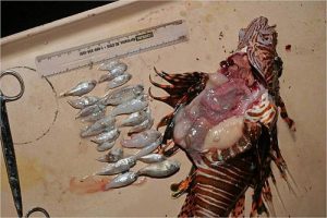
Lionfish Eat Everything - Stomach ContentsLionfish are voracious predators! They will eat almost any marine creature it can fit into its mouth, up to 2/3 of its own body size and include fish that are commercially important- juvenile snapper, grouper, flounder and other common “table fish;” recreationally important – juvenile billfish, mahi mahi, wahoo, jacks, tuna and other prized “game fish” for anglers as well as the creatures divers enjoy seeing like octopus, sea horses, lobsters, crabs, etc; and ecologically important – the cleaner fish and shrimp that keep bigger fish healthy by removing parasites and other disease causing organisms and the grazing creatures that keep the reef free of algae and other growth that would otherwise smother the reef to death.

They are gluttonous feeders, meaning that they will eat as much as they can physically manage as often as they are able; lionfish stomachs can expand up to 30 times their normal volume. Native marine creatures and fish stock do not instinctively recognize lionfish as predators and are easily hunted. Science has demonstrated that a single lionfish can reduce marine creatures by 80% to 90% in its range within 5 weeks. When food is scarce, a lionfish’s metabolism can essentially crawl to a stop; Lad Akins, Director of Special Projects at REEF, said in one presentation not long ago that studies have shown that lionfish can live without food for up to 3 months and only lose 10% of their body mass.

Here’s the bottom line:

Invasive lionfish are disastrously out-breeding, out-living, out-eating and out-competing every other native fish in the Western Atlantic Ocean, Gulf of Mexico and the Caribbean Sea. If left unchecked lionfish will ultimately cause the destruction of the reefs, native fish stocks and the livelihoods of everyone that depend upon them.

Where are lionfish originally from? Where do lionfish come from?

The lionfish invasion consists almost entirely of two species of lionfish, Pterois volitans (red lionfish) and Pterois miles (common lionfish or devil firefish). Virtually indistinguishable from each other outside of the laboratory, P. volitans is thought to make up approximately 93% of the total invasive population. Both the red lionfish and common lionfish come from the oceans of the Indian & South Pacific Oceans (Indo-Pacific) and the Red Sea as depicted in this map of their native range and habit:


How long have lionfish been considered a problem or threat? When did lionfish get here in the Western Hemisphere?

The first documented sighting of lionfish in the United States occurred in October of 1985 when a crab trap fisherman, Richard Nielsen, fishing off of Dania, Florida, brought up a red lionfish in a crab trap. While this is the first confirmed sighting, there are unconfirmed stories of very rare lionfish sightings along the east coast of the United States by fishermen and scuba divers from as early as the ’70s. It’s safe to assume that non-native lionfish were a threat to the local environment the very day they were introduced.

Click on the video below to watch the lionfish population explosion as it occurred between 1985 and 2013, pay particular attention to the progression through the years beginning with 2007.


This video is based upon visual sighting data reported to REEF, NOAA and the USGS; considering that lionfish can live to depths of at least 1000 feet or 305 meters, the actual lionfish population is probably much worse.

How did lionfish get to the Western Atlantic Ocean, into the Gulf of Mexico and spread throughout the Caribbean?

How lionfish were first introduced into the Western Hemisphere is a topic of much debate and consternation. One theory is that several lionfish somehow escaped and were swept into the sea when a private aquarium in Florida was destroyed during Hurricane Andrew in 1992. This is likely NOT the cause for the lionfish invasion because confirmed lionfish sightings date back to 1985.

Another theory is that lionfish, or more probably lionfish egg masses, were transported into the Western Atlantic Basin in ship’s ballast tanks. This theory, as it relates to lionfish, cannot necessarily be disproven and there is plenty of proof that non-native marine species have been spread through the ballast tanks of commercial ocean going vessels. Ultimately, a severe lack of genetic diversity in the invasive population tends to lead scientists in other directions looking for the source and cause.

Today, most scientists agree that the lionfish invasion was started by lionfish removed from home aquariums and disposed of into the Atlantic ocean around Southeast Florida.

Lionfish egg masses and larvae were then distributed across the Western Atlantic Basin via ocean currents. Lionfish are now found as far north as Rhode Island and as far south as Brazil. Wintertime ocean temperatures seem to be the only limiting factor of their distribution as it is believed that lionfish are unable to survive water temperatures below approximately 50 degrees Fahrenheit or 10 degrees Celsius

Do lionfish have natural predators in the Indo-Pacific Oceans and Red Sea?

Natural predators in the Indo-Pacific and Red Sea that are known to eat lionfish include sharks, cornetfish, grouper, large eels, frogfish and other scorpionfish. There is speculation that large snapper and some species of trigger fish eat lionfish in their native ranges as well.

What is being done to control lionfish? What can be done about lionfish? Can we train other native fish to eat lionfish?

It doesn’t appear likely that we can train native fish to hunt and eat healthy lionfish. It has been tried with sharks and groupers. There are several problems associated with this approach; first, in one experiment in which researchers placed a small lionfish in a tank of several hungry grouper, the much larger predators actually cowered away from the aggressive lionfish and avoided it almost to the point of starving to death before the researchers intervened. Secondly, fish do not train their offspring to hunt like a mammal does. There is really know “transfer of knowledge” and every new generation of predator would have to be trained. Thirdly, ad hoc training by inexperienced handlers only produces a perilous situation in which the “trainers” (mostly well-meaning divemasters and instructors) teach large and potentially dangerous predators to equate lionfish hunters with food. In turn, these animals have become quite aggressive in locations across the affected area and have caused serious injuries to other divers and numerous close-calls. I don’t know about you, but I don’t want to be chased by sharks, eels and barracuda every time I go lionfish hunting. Lastly, stories of grouper eating healthy lionfish are becoming more frequent but a study very recently published indicated that the *number* of predators, i.e. grouper, are so low that they are having very little, if any, effect on the invasive lionfish population.

Absent any naturally occurring predator or environmental solution to control the exploding lionfish population and slow the lionfish invasion, it would seem that humans must actively target and kill lionfish through hunting, fishing and trapping.

Hunting with a speargun, pole spear, Hawaiian sling or other pointy object is the most effective. Lionfish are rarely caught on a hook & line or fishing pole but it does happen on accident. Experiments are underway to use special fish traps and larval traps, but the concern of unintended by-catch is always a concern.

Visit our lionfish hunting page for more information about tools, techniques and other considerations while lionfish hunting.

Are lionfish dangerous to humans? Do lionfish attack people?

Lionfish are not aggressive towards humans and we’ve never documented a story in which a lionfish has offensively attacked anyone. Lionfish have most certainly caused injuries to people out of self defense or by accident. Most often divers are stung by lionfish while hunting and a thrashing lionfish either gets off of the spear tip and blindly swims into the hunter while it’s trying to escape. Divers are also prone to being envenomated while trying to put a lionfish into a bag or storage device. Likewise, divers also get hurt when they are too close to a lionfish hunter at work and especially the lionfish at the end of his or her spear.

Divers and underwater photographers have been hurt because they either didn’t see a lionfish or got entirely too close to what they THOUGHT was a docile fish; with a lighting fast shake the lionfish has managed to get a spine or two into the diver and the pain sets in very quickly. If you mind your buoyancy, are aware of your surroundings and NEVER touch or molest marine creatures you will entirely avoid a very painful lesson.

While rare, unsuspecting swimmers and bathers in shallow water have been known to accidentally kick or step on a lionfish causing themselves injury.

People also tend to get stung by a lionfish when handling them after a hunt or while cleaning lionfish prior to eating them. It’s easy to get careless when handling what you think is a dead fish that surprises you with a final violent “death shake,” too. Our advice is to treat a lionfish like a gun: its ALWAYS loaded until the spines are removed and disposed of safely.

Are lionfish poisonous or venomous?

Lionfish are venomous, not poisonous. Venom must be injected into the body through bites, spines, fangs and stingers while poison must be inhaled or ingested (eaten, swallowed or absorbed) in order for the toxin to have any effect. Lionfish have needle-sharp spines that are capable of delivering a potent protein-based neuromuscular toxin.

Where are the venomous spines? How many dangerous spines does a lionfish have?

Invasive lionfish (P. volitans & P. miles) usually have 18 venomous spines in all – 13 long spines in the dorsal fin, 1 short spine in each of its pelvic fins and 3 short spines in the leading edge of the anal fin.


The pectoral fins, the fins that lionfish most often fan out to their sides, and the caudal fin (the tail) do not contain any venomous spines.

What will happen to me if I get stung by a lionfish?

Symptoms of being envenomated by a lionfish include the almost immediate onset of INTENSE pain followed by swelling, redness and bruising in the area of the of the puncture wound. Secondary symptoms associated with a lionfish sting can include shortness of breath, allergic reactions ranging from minor symptoms through very serious anaphylaxis, dizziness, nauseousness, fainting and, in isolated cases, temporary paralysis. Severe pain may last for several hours and slowly decrease over the course of 24 hours and may take days to completely subside.

It should be noted the severity and duration of symptoms can be directly correlated to the amount of venom delivered, how deep the spine(s) punctured the body and the “freshness” of the venom as well as the victims own constitution or sensitivity to the venom; the protein chains in the venom begin to breakdown after the lionfish dies and is exposed to air, heat or freezing temperatures.

Can I die from being stung by a lionfish?

For a reasonably healthy adult the chances of dying are very, very low… but you might be in so much pain that you want to. There have been no known fatalities caused by a lionfish sting, though the possibility does exist as a result of the effects of shock from the intensity of the pain or complications caused by an infection if left untreated.

How do I treat a lionfish sting? What is the proper first aid for lionfish stings?

Obviously, if you are scuba diving or freediving you must safely end your dive as soon as possible and get to a safe and stable place where you can call for emergency medical services if required.

First aid and treatment of a lionfish sting includes inspecting the puncture wound and removing any pieces of the spines that may have broken off and remain in the injection site. Control bleeding and immediately apply the hottest water you can stand without scalding or burning your skin. Immersing the affected area is best but if it is not possible due to circumstances or the wound’s location, applying a clean cloth soaked in hot water is most effective. Using hot packs or a hair dryer may provide some much needed relief as well. Do not cause further damage by burning yourself.
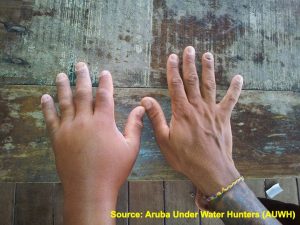
Lionfish Sting Provided by Aruba Under Water Hunters (AUWH)Despite the amount of swelling, DO NOT APPLY ICE or cold compresses until the pain has completely subsided – this will only make the pain worse and prolong the amount of time you will suffer! Common home remedies like urine, vinegar, baking soda, etc. are rarely effective against protein-based neurotoxins; they are not recommended and should be avoided.

If desired, taking over-the-counter pain medications such as aspirin or tylenol can help manage the pain if you can tolerate them.

Clean the wound thoroughly as recommended for any injury caused by a marine animal or organism in order to prevent infection.

Seek medical attention immediately if you suspect anaphylactic shock (extreme allergic reaction), shortness of breath or trouble breathing, decompression illness, fainting or if the pain becomes unbearable. Additionally, if the wound appears infected or the skin surrounding the injection site appears to be blackening, putrefying or being eaten away (necrosis or tissue death).

Quite frankly, seeking medical attention is NEVER a bad idea in the event of a lionfish sting and the WLHA highly recommends it.

Can you eat lionfish? How is lionfish cooked or prepared?

Absolutely! Lionfish is delicious and can be prepared in so many ways! Ceviche, sushi, sashimi (raw), fried, baked, in soup… Lionfish is a very mild white meat with no “red line” that can be prepared just about any way snapper, mahi mahi (dolphin fish or dorado) and grouper can be prepared.

For more information see our article describing what lionfish tastes like, our lionfish cleaning and preparation page  as well as our lionfish recipes page.

Is eating lionfish dangerous? Are lionfish poisonous like puffer or fugu dishes?
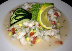
Lionfish Ceviche from La Perlita in Cozumel, MexicoThe common myth that eating lionfish is somehow deadly is very wrong. Lionfish are not poisonous to eat and there is absolutely no risk of keeling over and dying from a lionfish not being prepared or cooked correctly! Even ingesting lionfish venom would not present any health risks because the venom would be denatured almost immediately when it came in contact with stomach acid (though we personally would be concerned about having fresh venom come into contact with any open sores or cuts inside of the mouth or gums… yikes!).

Lionfish are extremely safe to eat in most areas, however, just like eating snapper, grouper, barracuda and over 400 other species of fish identified as potential carriers caution must be exercised in those limited areas where ciguatera fish poisoning (CFP) is a problem. Local fishermen, divers and restaurants will often be aware if ciguatoxins cause local seafood concerns.

Do you have a question about lionfish that you would like answered? This email address is being protected from spambots. You need JavaScript enabled to view it.!

About the Author:

Scott Harrell is the Executive Director of the World Lionfish Hunters Association. He was a high profile private investigator and business consultant who now lives and "slow travels" throughout the Caribbean and Latin America hunting lionfish and working with dive centers on behalf of the WLHA. Scott has been a dive instructor since 1995. He can be reached via email at This email address is being protected from spambots. You need JavaScript enabled to view it..
Hits: 4860
0
Source: Maritime Executive Magazine                        

Photo: Merchant ships fill San Francisco harbor, 1850–51.


Construction workers digging beneath the streets of downtown San Francisco have uncovered a nearly intact boat believed to be from the Gold Rush era in the mid-19th century, officials said on Thursday.


The 23-foot (7-metre) wooden vessel was unearthed earlier this week as crews shoveled beneath the roadway of Folsom Street in the city's South of Market district to prepare for the development of residential towers.


After workers noticed the boat's outline, they dug around it by hand to minimize damage, and a conservationist was called in for further evaluation, said Lynn Cullivan, management assistant at the San Francisco Maritime National Historical Park.


"It's a totally lost piece of history that's interesting to keep alive," Cullivan said, adding the boat had some bad planks, "but basically it's intact, and that's really unusual."


It is not uncommon to find pieces of ships buried below street level in San Francisco, but it is extremely rare to find a boat in as good shape as this one, he said.


Cullivan said he believed the flat-bottomed cargo boat, called a lighter, came from the California Gold Rush period starting in the late 1840s when hundreds of ships landed in San Francisco Bay with passengers in search of new lives and precious metals.


"It's interesting to think that people in that day went down to the financial district of San Francisco, and they'd get in one of those little boats, and they'd row out," Cullivan said. "Today, no one would imagine doing that."


The lighter, which was powered by ores or towed, carried food and other supplies to land from large ships that could not get close to San Francisco's shallow shore. It was deemed obsolete in about 1860, when the city had developed piers that allowed big ships to pull up and unload.


If the lighter's wooden body is found to be strong enough to be transported and preserved, it will be taken by flatbed truck to the maritime agency's warehouse east of San Francisco in Livermore, where it will be kept safe and likely be put on display for public viewing in the near future, Cullivan said.


Reporting by Laily Kearney; Editing by Dan Whitcomb and Peter Cooney (C) Reuters 2013

Hits: 1987
0

Source: Maritime Executive Magazine

www.maritime-executive.com 


Archeologists working for the U.S. Army Corps of Engineers, Savannah District, aided by divers and salvage operations teams from the U.S. Navy, retrieved a 64-square-foot section of a Civil War ironclad warship from the bottom of the Savannah River here, the evening of Nov. 12. 


The divers worked in strong currents with near-zero visibility during the past week to assess the possibility of lifting a small piece of the Confederate ship's casemate for archeological testing. 


A crane lifted it onto a barge anchored near historic Old Fort Jackson on the eastern edge of Savannah. Experts estimate the piece weighs more than 5,000 pounds. 


Julie Morgan, a staff archeologist with the U.S. Army Corps of Engineers Savannah District, stands next to a 5,000-pound piece of the CSS Georgia, a Civil War ironclad scuttled in the Savannah River in 1864. 


The Confederate navy scuttled the CSS Georgia in 1864, as Union troops approached Savannah. The iron-covered ship remained on the river bottom until 1969, when a dredge removing sediment from the shipping channel struck a portion of the ship, according to Julie Morgan, staff archeologist for the Corps' Savannah District. A brief recovery effort in the late 1980s removed two cannons, various types of munitions and other artifacts. 


"This retrieval will play a major role in creating a research design to effectively remove the CSS Georgia before expanding the shipping channel along this stretch of the Savannah River," said Morgan. "It took a dedicated team working in some very tough conditions to bring this piece to the surface." 


Over time, the ship's casemate, the iron-covered upper portion of the warship, came apart. The small portion removed Nov. 12 will give archeologists the ability to assess the condition of the remainder of the ship, according to Morgan, and ensure the team follows protocols from the National Historic Preservation Act of 1966. 

Hits: 2068
0

Posted by on in Wrecks

There wouldn't seem to be many good reasons for designing a submarine to launch airplanes, but during the past one hundred years at least six countries have experimented with the concept some with surprising success.

Germany was first to try in 1915 when a floatplane pilot teamed up with a U-boat captain he'd met socially and flew his aircraft off the sub's deck. Since it was an unsanctioned trial no follow up flights were made.

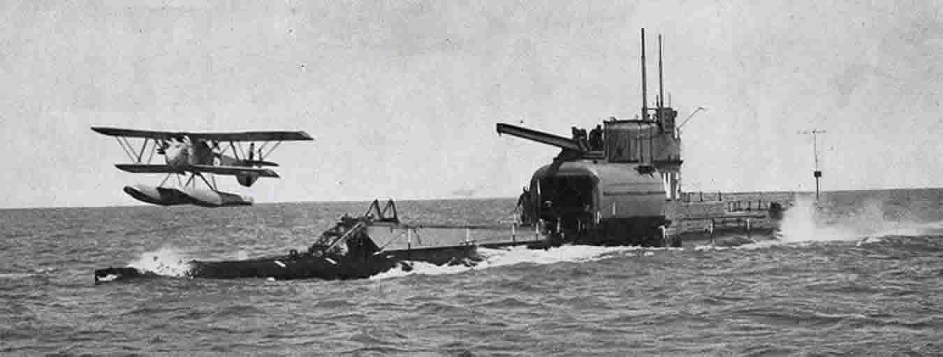
The English were next to try when the HMS E-22 launched two Sopwith Schneider seaplanes from her deck in April 1916 (see photo below). The experiment was not repeated, however, after the E-22 was sunk two days later by a German U-boat.
2013-03-14-HMSE22.jpg
The United States didn't begin its own sub-plane experiments until 1923 when the S-1 carried a Martin MS-1 biplane in a small on-deck storage container. Unfortunately, it took sixteen man hours to assemble the aircraft, which made the idea impractical since the longer a sub remains on the surface the more vulnerable she is to attack.

The first submarine fully capable of carrying, launching, and retrieving an airplane was Britain's M-2 (see photo below). Unfortunately, her Parnall Peto floatplane had difficulty landing in more than a light breeze--a non-starter for a sub operating in the North Sea. But the M-2 also suffered from a fatal design flaw which wasn't discovered until the sub vanished one morning in January 1932.
2013-03-14-M2submarine.jpg
The M-2 was eventually found three miles off the coast of England in one hundred feet of water. Her hangar door, which was located too close to the sub's waterline, was open as was a hatch leading from the hangar into the sub. Presumably, the M-2 was accidentally flooded causing her sixty man crew to perish along with England's desire for further experimentation with plane-carrying subs.

Germany, Great Britain, the United States, Italy, and France all investigated some kind of sub-plane combination with poor results. It wasn't until Japan picked up the gauntlet that the concept bore fruit. Subs played an important scouting role in the Imperial Japanese Navy, which saw them as a means of locating and destroying an enemy fleet before it reached their island nation. Since a sub-launched floatplane could significantly increase a sub's scouting range, Japan spent the next twenty years perfecting the combination.

Starting with a Heinkel seaplane purchased from Germany in 1923, Japan rapidly progressed to the I-7 and I-8, the first Japanese subs built from scratch with a catapult and water tight deck hanger. By December 7, 1941, Japan had 11 plane-carrying submarines deployed at Pearl Harbor with three times that number under construction.

But it wasn't until Admiral Yamamoto developed Japan's I-400 class submarine as a follow up to his attack on Pearl Harbor that the ultimate achievement in underwater aircraft carriers was realized.

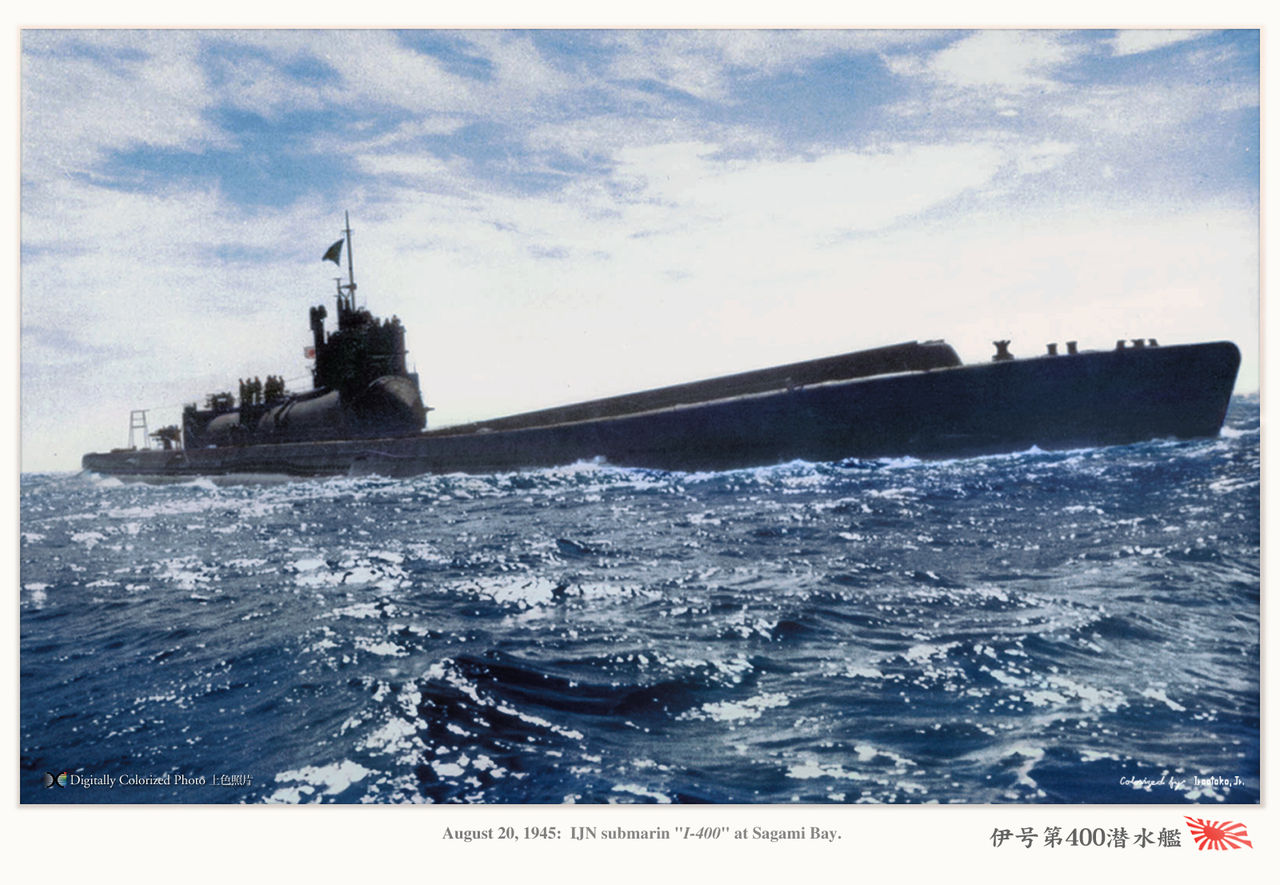
Over 400 feet in length, the I-400s were the largest submarines ever commissioned until the Ethan Allen class in 1961. Purpose-built to launch a surprise aerial attack against New York City and Washington, D.C, each sub could travel one and a half times around the world without refueling, and carried three Aichi M6A1 attack planes in a water tight deck hangar (see photo below).
2013-03-14-Waybigger.jpg
My new, non-fiction book, Operation Storm: Japan's Top Secret Submarines and Its Plan to Change the Course of World War II, recounts the little known story of the I-400 subs from conception to deployment. But people hearing about these subs for the first time often find the story too incredible to be true. Sub-launched airplanes? Underwater aircraft carriers? It sounds more like an episode from the old sci-fi series Voyage to the Bottom of the Sea (which boasted its own flying sub) than anything Japan might undertake.

But Japan's I-400 subs were actually built, launched, and commissioned. In fact, they were on their way to complete their mission when the war ended. Even then, the I-401, the squadron's flagship, refused to surrender, went rogue, and almost triggered a resumption of hostilities.

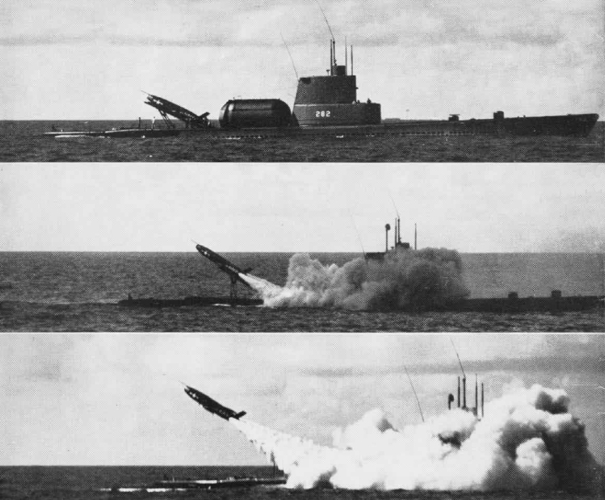
After World War II ended, the United States sailed two of the I-400 subs from Tokyo to Pearl Harbor for further study. As a result, the Regulus missile program, which launched nuclear-tipped missiles from a surfaced sub's water-tight deck hangar (see photos below), owes a debt to the I-400s. The Douglas Aircraft Company, which designed an attack plane that could be housed and launched from a Regulus sub's missile hangar, owes a similar tip of the hat.
2013-03-14-SubLaunchedRegulusMissile.jpg
In fact, Japan's realization that a submarine could be used to launch an offensive attack against an enemy's city is the same strategy our sub-based nuclear deterrent relies upon today. In other words, airplane-carrying subs may be a relic from the past, but their legacy continues sixty years later making them not such a crazy idea after all.

Hits: 2611
0


Hits: 1867
0

Posted by on in Wrecks
South Africa - Australia - South Africa

This is the first evidence of inter-continental trans-oceanic return migration of Great White Sharks (Carcharodon carcharias) and the implications of this discovery were extremely important for conservation efforts to help list this species on the CITES Appendix II in October 2004.

The Wildlife Conservation Society in association with Marine and Coastal Management, the White Shark Trust, the Universities of Cape Town and Pretoria and the South African Museum tagged white sharks off the Western Cape (South Africa) between June 2002 and November 2003 with 25 pop-up archival satellite transmitting (“PAT”) tags, 7 near-real-time satellite (“satellite”) tags and 25 acoustic tags to study their spatial-dynamics. Using high-resolution photographic fingerprinting techniques the White Shark Trust also recorded the daily presence/absence of individual White Sharks off Gansbaai (34°39’S 019°24’E; Western Cape) since October 1997.

On the 7th of November 2003, a circa 380 cm (about 12.5 feet) total length female Great White Shark was tagged with a PAT (Pop-up Archival Transmitting) satellite tag in an area known as Haibaai near Dyer Island, Gansbaai, Western Cape, South Africa.

On the 28th of February 2004, the PAT tag released itself from the Shark at the pre-programmed date. The pop-up location indicated that this Shark travelled in 99 days to a location 2 km from shore and 37 km south of the Exmouth Gulf in Western Australia (22°01’05”S 113°53’13”E) about 11'000 kms from her tagging site.

Read the scientific article published in Science on the 7th of October 2005 for more information...
Moreover, this Shark is well known to the White Shark Trust photographic identification database as she has been visiting Dyer Island since 1999 when she was first recorded. On the 20th of August 2004, Michael Scholl was conducting his ongoing fieldwork around Dyer Island when he spotted the very distinctive dorsal fin of this same Shark.

The White Shark Trust identification reference number for this Shark is WST/1308. The Wildlife Conservation Society reference number for the tag is WCS/P12. But in honour of Nicole Kidman, famous Australian actress and known for her love for Sharks, we decided to call her 'Nicole'. We will refer to this Shark as Nicole or 1308/P12 in this article.

The present web page discusses these results in depth and presents some additionnal information and photographs that could not be included in the published article. Sections of the following text form part of the original published article. Contact us for a PDF version of the original article published in Science or read it online.

Figure 1 shows the approximated path followed by Nicole from the tagging site in Holbaai on the 7th of November 2003 to the PAT pop-up site just off the west coast of Australia on the 28th of February 2004. This path is the result of complicated calculations from the geolocation data collected by the PAT tag during the 99 days.

Unlike a SPOT (Smart Position Only Tag) satellite tag which needs to break the water surface to emit a signal that can be picked up by the ARGOS satellite system to get a location, a PAT tag is an inactive satellite tags until the pop-up date at which time the tag detaches itself from the Shark and floats to the surface and only then starts transmitting.

During the attachment period, the PAT tag will record three parameters: swimming depth, ambiant water temperature and light intensity. All the depth and temperature information is summarised for each day and stored in the internal memory (hence the archival name). From the light sensor, the tag estimates sunrise and sunset times for every day and these are also stored in the internal memory.

Figure 1a: Return intercontinental transoceanic migration of Shark 1308/P12 between Dyer Island (Gansbaai, Western Cape, South Africa) and the northwestern coast of Australia plotted on a topographic map. Black line is an estimated path followed by the Shark from South Africa to Australia from analysing the geolocation data recorded by the PAT tag.
Figure 1b: Transoceanic migration of a white shark from South Africa to northwestern Australia and possible first leg of a second transoceanic-migrating shark. Geolocation-estimated positions of shark 1308/P12 (black dots) based on light-intensity records and possible path during this migration (solid line). The start of another possible migration to Australia is shown by the auto-release location of the PAT tag from shark P3 (blue line and square). Tagging and popup dates are: 1308/P12: 07/Nov/2003 and 28/Feb/2004; and P3: 14/Apr/2003 and 25/Dec/2003. Sea Surface Temperature (SST) is an average composite of daily 4-km resolution MODIS data for 23/Nov/03-28/Feb/04. Southwest Indian Ridge shown as white depth contours (100-2,000 m). Scale bar represents 6,000 km.
Figure 1c: Transoceanic migration of a white shark from South Africa to northwestern Australia. Differential time-at-depth patterns during the coastal (left) and oceanic (right) legs of Shark 1308/P12 showing strong preference for the first 0.5 m of depth, then for depths of 500-750 m during oceanic travel. Minimum (black line and squares) and maximum (bright blue line) depths and minimum temperature (orange dots) visited by 1308/P12 during the coastal and oceanic legs of its movement; all data in 6-hr periods; arrow marks beginning of transoceanic migration.

At the pre-determined pop-up date, the tag detaches itself from the Shark and floats to the surface. This is when the PAT tag starts transmitting all the data accumulated and stored in the internal memory. The ARGOS satellite system will pick up the signal and will be able to pinpoint the location of the now drifting PAT tag.

Hence, with PAT tags, we only have two very precise GPS (Global Positioning System) locations for the Shark: the tagging site (from the boat GPS) and the pop-up location. So how did we plot the path shown in figure 1?

From the estimated sunrise and sunset times calculated and recorded by the tag... These times can be compared to the internal clock which is synchronysed to the tagging site for example. As the Shark is moving east or west (longitude), sunrise and sunset times will vary and an estimated location can be calculated. The location is not precise and only long range movements can be analysed with this geolocation system. This geolocation can further become more precise when integrating the water temperature and maximum depth (the Shark is likely sometimes to go to the sea floor if diving) data into a global GIS system. But the resulting movement plot will never be very precise, it will remain an estimated path.

PAT or Pop-up Archival Tag is ready for deployment on the tagging pole.
Shortly after the PAT tag pop-up date at the end of February 2004, the information collected and stored started to be transmitted back to the ARGOS headquarters and further forwarded to Dr. Ramón Bonfil at the Wildlife Conservation Society (WCS) headquarters in New York. Dr. Ramón Bonfil is the project leader of the South African satellite tagging project in collaboration with Marine and Coastal Management (DEAT-MCM). The White Shark Trust, the University of Cape Town, the South African Museum and the University of Pretoria are also part of this collaborative effort to better understand the movement patterns of White Sharks using satellite tracking technology.

The news of this extraordinary voyage from South Africa to Australia were extremely exciting, but had to be kept quite at the time due to publishing constraints.

Dr. Ramón Bonfil of the Wildlife Conservation Society holding a PAT tag on the tagging pole ready for deployment.
This shark’s circa 10,800 kilometer course entailed an anticlockwise semi-circle 500+ kms south of Cape Agulhas (the Southernmost point of the African continent), followed by an extraordinarily direct eastward path towards NW Australia, indicating that white sharks do not need oceanic islands as gateways for transoceanic migration as previously hypothesised. Nicole travelled at a minimum speed of 4.7 km/h during this journey, the fastest sustained long-distance speed recorded among shark species and comparable to that of some of the fastest swimming tunas.

Photographic fingerprinting allowed identification of this shark back at its original tagging site off Gansbaai on 20 August 2004 (see below and figure 3). This migration circuit is remarkable not only because it starts and ends in the exact same location but also because it is the fastest known transoceanic circuit-migration among marine fauna, taking just under nine months to complete a circa 20,000 km trip.

Figure 1a and 1b illustrate the hypothetical plot (solid black line) of the migration route followed by Shark 1308/P12 over a topographic (depth) map and SST (Sea Surface Temperature) map respectively, from South Africa to Australia. Geolocation positions (black dots) obtained from the PAT tag's light sensor are indicated in Figure 1b from which the estimated plot (solid line) was calculated.

We analyzed the satellite-transmitted summary data to reveal the diving pattern of this shark and discovered that daily, during the onward journey from South Africa to Australia, the Shark took frequent deep-dives, reaching record maximum depths (980 m) and ambient temperatures (3.4°C), and spent 18% of the time at depths of 500-750 m (Figure 1c). Surprisingly, it spent significantly more time just below the surface (top 0.5 m) while in oceanic waters (61%) than when it was in coastal waters (23%), swimming most of the time (66%) above 5 m during this trip. This preference for just-below-surface-swimming during oceanic travel constitutes a previously-unknown behavioural pattern for white sharks and suggests that similar to other vertebrates, it may have used visual stimuli, perhaps in the form of celestial cues, as an important navigational mechanism in addition to, or instead of following gradients in earth’s magnetic field as commonly accepted for sharks.

Michael Scholl and Shark 1308/P12 on Lamnidae, the White Shark Trust research boat, on the 21st of August 2004.

Michael Scholl of the White Shark Trust started looking at the photographic identification database which he has been building since 1997. Shark 1308/P12 is a well known Shark to Michael Scholl's fieldwork and database. She was recorded for the first time on the 19th of September 1999, five years prior to the present news.

This Shark has been sighted 38 times over the past six years (1999 - 2004). Figure 2 shows the periods when Shark 1308/P12 was observed in the Dyer Island area. The numbers indicate the number of days this Shark was observed each month.

1999
2000
2001
2002
2003
2004
January
February
March
April
May
June
1
July
2
1
August
1
3
3
September
1
1
3
1
1
October
2
1
2
8
November
1
1
1
2
December
1
1
Figure 2: Presence period of White Shark 1308 / P12 at Dyer Island from the photographic identification database from 01 January 1999 through 31 December 2004. Numbers indicate the number of days this Shark was observed for each month.

A clear and certainly very interesting pattern emerges from this chart: Nicole has been observed every year since 1999 between June and December, but never during the rest of the year (January through May). Remembering that this Shark was tagged in November, turned up in Australia at the end of February, and sighted back in South Africa in August, we can hypothesise that this Shark might be taking this return trip to Australia every year... for maybe and at least the past five years...

Remembering also that a 380 cm TL (total length) female White Shark is still immature as far as we know... Why would a Shark undertake this yearly migration?

The White Shark Trust field research team (from left to right: Callum Call, Holly Frank, Andy Brandy Casagrande, James van den Broek are field research assistants of the White Shark Trust, and Michael Scholl in the back on the riht) with Shark 1308/P12 swimming past Lamnidae. Photograph taken by Dyer Island Cruises, the local boat based Whale Watching company.

Figure 3 illustrates the photographic identification methodology designed and developped for White Sharks by Michael Scholl, and demonstrates that the Shark tagged with PAT tag P12 on the 7th of November 2003 is indeed the same Shark photographed on the 20th of August 2004 after her return trip to Australia.

Figure 3 compares one identification photograph taken the day of the tagging on the 7th of November 2003 to another picture taken on the first subsequent observation on the 20th of August 2004.

Figure 3a compares the trailing edge of the first dorsal fin. The white lines link corresponding notches between the two identification photographs, clearly demonstrating that the two images are from the same Shark. Figure 3b shows the left side of the Shark's body behind the dorsal fin where PAT tag P12 was inserted on the 7th of November 2003. On the bottom picture, the tag is absent as it had popped-up (28 February 2004) nearly six months prior to the second picture being taken (20 August 2004). Nevertheless, three apparent white scars are still clearly visible: tag insertion point, scratch scar from the overgrown tag lead and from the buldging tag flotation.

Figure 3c and 3d further illustrate the positive identification of this Shark between 07/11/2003 and 20/08/2004 by comparing small pigmentation features present on respectively the left and the right side of the first dorsal fin.

Figure 3a: Photographic fingerprints of Shark 1308/P12 at tagging (07 November 2003) and upon return to tagging location in Gansbaai (20 August 2004) after its transoceanic migration to Western Australia: Trailing edge of first dorsal fin showing unique notch pattern allowing identification; white lines connect corresponding notches on both photographs;
Figure 3b: Photographic fingerprints of Shark 1308/P12 at tagging (07 November 2003) and upon return to tagging location in Gansbaai (20 August 2004) after its transoceanic migration to Western Australia: Position of PAT tag after tagging (top panel), and healing scratch scars left after tag release (bottom panel);
Figure 3c: Photographic fingerprints of Shark 1308/P12 at tagging (07 November 2003) and upon return to tagging location in Gansbaai (20 August 2004) after its transoceanic migration to Western Australia: Left side of first dorsal fin with magnified details (left inserts) showing unique black pigmentation pattern aiding fingerprinting;
Figure 3d: Photographic fingerprints of Shark 1308/P12 at tagging (07 November 2003) and upon return to tagging location in Gansbaai (20 August 2004) after its transoceanic migration to Western Australia: Right side of first dorsal fin with magnified details (left inserts) showing unique black pigmentation pattern aiding fingerprinting.
Logged photographic data show shark 1308/P12 was a seasonal visitor (June-December) to the Gansbaai area (Figure 2), having been recorded 28 times during 1999-2004, suggesting that it is a South African shark and that the transoceanic circuit-migration could be an annual natal-homing event.

A second PAT-tagged shark (unsexed, ca. 200-230 cm TL; number P3) travelled to an offshore location 242 km SE of Port Elizabeth where its tag detached on 26/Dec/2003, in what appeared to be the start of a migration towards Australia (Figure 1b).

The transoceanic circuit-migration of Nicole is of key importance: it is the first direct evidence of connectivity between widely-separated white shark abundance centres, critical for our understanding of white shark population structure and for conservation and management. Our results also confirm philopatry in White Sharks.

In addition, the size of Shark 1308/P12 suggests it could reach sexual maturity soon and we speculate that it could eventually mate off Australia. In this event, the likely return of this shark to give birth off South Africa would provide further support to general reproductive behaviour theories of marine fauna and signal the need for protection of pregnant females facilitating a crucial genetic link between distant subpopulations.

Michael Scholl of the White Shark Trust in a close-encounter with Shark 1308/P12 on the 21st of August 2004 after the Shark's return to South Africa
On a smaller scale, white sharks frequently perform long-distance coastal circuitmigrations (>2,000 km) from well-known abundance sites in the Western Cape, first northeastwards using well-defined underwater corridors along the continental shelf and sometimes very close to shore, to waters off KwaZulu-Natal and beyond, then returning to Western Cape sites after periods of 4-6 months (Figure 4).

Two out of six satellite-tagged sharks that were tracked for >2.5 months and one PAT-tagged shark showed long-distance coastal circuit-migrations back to their exact original tagging site.

Shark S1 (a 284 cm TL female) tagged in Mossel Bay (34 deg 08 min S 22 deg 07’ min E) during May 2003 completed the first directly-observed long-distance circuit-migration for a shark or ray species, moving in 65 days to waters just northeast of Delagoa Bay (Mozambique) and outside the South African EEZ where white sharks are legally protected (Figure 4a). It returned to Mossel Bay 162 days after tagging and was photographed with the transmitter still attached to its dorsal fin.

Another shark double-tagged with satellite and acoustic tags in Mossel Bay during May 2003 (number S2, a 310 cm TL female), followed a close-inshore path to the Tugela Bank where it last transmitted 46 days after tagging. This shark was recorded by our acoustic-tag bottom-monitors back at its original tagging site 123 days after tagging (Figure 4a).

Shark P11 (a PAT-tagged 388 cm TL male) moved between Gansbaai and the Tugela Bank between 5/11/2003 and 31/01/2004 (Figure 4b), then was re-sighted, captured and fitted with a satellite tag in Gansbaai on 26/05/2004.

Individual white sharks commonly disappear from Mossel Bay and Gansbaai but eventually return to these preferred sites after several months of absence (Figure 5), further suggesting that these long-distance circuit-migrations are common.

Figure 4a: North-eastward long-distance circuit-migrations of South African sharks. Tracks of two satellite-tagged sharks showing long-distance circuit-migrations and crossing to Mozambique; shark S1 left Mossel Bay after tagging (24/May/2004), moved rapidly to Bird Island residing within a limited area (385 km2) for 27 days, continued northeast along the shelf-edge then in deep water beyond the Agulhas Current, reaching Mozambique 65 days after tagging. Transmissions ceased after 11 days in Mozambique to resume at Bird Island 62 days later; shark S1 returned to its original tagging location on 2/Nov/2003. Shark S2 tagged on 31/May/03 with satellite and acoustic tags, travelled steadily along the coast to the Tugela Bank in 37 days where it ceased transmitting 9 days later, and was recorded by bottom-receivers back in Mossel Bay on 1/Oct/04. Red star is tagging location; dashed line is movement between long periods without transmissions.
Figure 4b: North-eastward long-distance circuit-migrations of South African sharks. Movements of 15 PAT-tagged sharks that travelled to shelf waters; yellow stars show tagging sites, black circles pop-up locations, pink triangles represent two tags popping-up in the same location.
Four additional PAT-tagged sharks (numbers P2, P5, P10, P16) travelled to points close inshore scattered along the Eastern Cape and KwaZulu-Natal. Their movements and those of sharks S1, S2 and P11 indicate that white sharks might be using the most-parsimonious route along the continental shelf and close inshore (avoiding the strong south-bound Agulhas Current) when travelling towards the Tugela Bank or further north (Figure 4b). The relative large number of white sharks moving to the rich environment of the Tugela Bank which hosts important fishery resources and serves as nursery ground to a number of teleosts and elasmobranchs suggests that these long-distance coastal circuit-migrations might be feeding-related events.

Other white-shark’s spatial-dynamics patterns include small-scale return migrations and site fidelity. Four satellite-tagged sharks showed small-scale return migrations (<1,000 km) including one shark making a short westward trip and returning to its tagging site after travelling 19 days and 970 km, and three other sharks moving alternatively for periods of 75-201 days between close-to-shore Western Cape locations < 200 km apart.

Site fidelity is evidenced by the remarkable return of shark 1308/P12 to Gansbaai, as well as by shark S1 in its repeated visits to and residency in a small area east of Algoa Bay (Bird Island) and Mossel Bay (Figure 4a) and by three PAT-tagged sharks (numbers P13, P8 and P1; Figure 4b) and an additional satellite-tagged shark that remained in their tagging locations for periods of 29, 33, 75, and 32 days respectively. We found additional evidence for site fidelity in the extended residence of white sharks in Gansbaai (up to 68 days) and Mossel Bay (up to 211 days) and their propensity to return to these areas after considerable periods of absence (Figure 5).

Figure 5a: Residence times of white sharks in two high-abundance areas in the South African coast, showing site fidelity and periods of absence followed by return. Presence-absence of 25 acoustically-tagged sharks in Mossel Bay. Maximum residence was 211 days (sh-13); maximum absence with a return was 95 days (sh-16). Numbers in brackets on the y axis are visually-estimated total lengths in cm; starting date for x axis is 1/Jun/2002; solid squares are males, empty squares females, circles unsexed sharks.
Figure 5b: Residence times of white sharks in two high-abundance areas in the South African coast, showing site fidelity and periods of absence followed by return. Presence-absence of 36 sharks photographically fingerprinted off Gansbaai (Dyer Island and neighbouring areas) for which records span more than 3 years. Maximum residency (absence of less than one week not considered) was 64 days (shark number 36), maximum absence with a return was 1'381 days (shark number 33)..
Management of white sharks, and perhaps many marine top-predators, can not be effected locally, or even regionally. Our studies show that we do not clearly understand the way in which identified populations, or subpopulations, are connected. Long-distance and transoceanic migrations expose great whites to increased risk of mortality as sharks migrate out of domestically-protected waters in South Africa into neighbouring or remote countries sometimes located across entire ocean basins.

An increasing global demand for shark products, coupled with our findings, suggest that global protective measures, such as the CITES Appendix II listing, were needed to ensure the effectiveness of local protective legislation and management regulations currently in place in a handful of countries.

Furthermore, the possible genetic flow between distant white shark subpopulations likely plays a pivotal role in the maintenance of their genetic variability. Its disruption via the extirpation of one of these subpopulations, or from the killing of the migrating sharks (especially pregnant females), could have disproportionate negative consequences for biodiversity and conservation, and further highlights the need for more effective and broader management and conservation measures for marine apex-predators that include multinational and international waters.

Click on the image above to read about updates of Nicole
Methods

Pop-up archival tagging

Pop up archival tags have been described in detail elsewhere. Briefly, these instruments record temperature, pressure (translated to depth) and light intensity every 15-120 sec for the period of deployment and automatically release themselves at a pre-programmed date. Once they float to the surface they transmit a summary of the recorded data to polar-orbiting satellites carrying the Argos System.

PAT tags built by Wildlife Computers, Redmond, WA were attached by inserting a dart on the shark’s back just below the base of the first dorsal fin as the shark swam next to the vessel. PAT tags were programmed for deployment periods of between 9 and 53 weeks and data collection frequency was set to either every 30 or 60 sec depending on deployment period. Tags were programmed using temperature bins with upper limits at 0, 5, 7, 10, 12, 15, 17.5, 20, 22, 24, 27, and 30° C; depth bin upper limits were 0, 0.5, 5, 10, 20, 30, 50, 100, 200, 500, 750, and 900m.

Sharks were attracted to our vessel by releasing a trail of fish oil, shark liver or other marine products, then lured into tagging position by pulling a rope with a large bait. The size of PAT-tagged sharks was visually estimated by 3 qualified observers and an average or range was recorded.

Satellite tagging

Two types of satellite tags built by Wildlife Computers were used.

Smart Position and Temperature Transmitting (SPOT) tags measure ambient temperature from –2.2 to +50 °C, with a resolution of 0.2 °C. SPOT tags were deployed disabling the temperature recording program in order to maximize battery life.

Satellite Depth Recording (SDR-T16) tags record and summarize data on dive depth and duration, and time spent at user-programmed depth ranges up to 1,000m. Summary data for the previous 24 hrs is sent with every transmission. SDR tags were programmed using depth ranges with upper limits of 0, 8, 12, 16, 20, 52, 100, 200, 500 and 760 m.

Both types of satellite tags transmit radio signals to the Argos System at 9 frequencies of 40-45 sec; a salt-water switch allows the instrument to send a transmission whenever it clears the ocean surface.

Sharks were attracted to the surface as described above, where individuals were selected and caught on baited hooks and lifted out of the water using a purpose-built metallic cradle fixed to the side of a research vessel. Satellite tags were fixed to the first dorsal fin using nylon pins, brass washers and steel nuts. The choice of metals intends to ensure tag-shedding after approximately 9-12 months. Each shark was measured on a straight line to the nearest cm for fork and precaudal length.

Acoustic tagging

A continuing acoustic telemetry study has been conducted in Mossel Bay since June 200114. Six VR2 bottom-monitors (VEMCO, Shad Bay, Nova Scotia) were placed between 34° 07-15 S and 22°06-08 E and two others were added in June 2002.

Acoustic transmitters (V16, RCODE 69 kHz, VEMCO) were similarly attached as for PAT tags. Acoustic pulse-rate was set at 40-70 seconds and battery life was estimated at 14 months.

Bottom-monitors archived the presence of tagged white shark within a 400 m range (environmental conditions may result in a wide range of detection distance). A shark was considered present if a single detection at any bottom-monitor was archived on a given day.

Photographic Fingerprinting

White sharks were identified off Gansbaai (Dyer Island and neighbouring areas) using a photographic fingerprinting methodology based mainly on features of the first dorsal fin’s posterior margin and other fin characteristics. Attraction was similar to that described above.

Photographs recorded both sides of the first dorsal fin whenever possible using either a 35 mm camera and slide film, or a high-resolution digital camera. Body markings and sketches of any recognizable features completed the identification record.

Data comprised 900 fieldwork days (average of 3.5 days/week) and 4,024 hours of observation in the field (average 4.5 hours/day) during the period 6/Oct/97-28/Feb/04.

No fieldwork was conducted during the following 10 periods: January-July 1998, March 1999, mid May 2000-mid June 2000, 20 September 2000-6 October 2000, mid March 2001-early May 2001, November 2001, April 2002-mid May 2002, 14-31 December 2002, March 2003, second half of November 2003, and mid-January early February 2004.

Acknowledgements

Financial support for the PAT and satellite-tag study was provided by the Roe Foundation, WCS, and the South African Government. A complete list of sponsors for the photographic-ID study is available here. The acoustic-tag study was financed by the South African Government and contributions from IFAW, WWF, and PADI Aware.

The authors’ appreciation goes to: the Natal Sharks Board and particularly Sheldon Dudley, Geremy Cliff, Kevin Cox and Wayne Harrison for valuable field-work assistance and helpful discussions in the satellite-tag study, and to Sheldon Dudley for assistance in the design and supervision of the acoustic-tag study; to Andre Boustany, Heidi Dewar, John Stevens, David Holts, Lee Hulbert, Rachel Graham and Michael Domeier for advice and help with tagging methodologies and equipment; to Barbara Mangold (formerly WCS), Chap Masterton, Sven Parsons, Pieter Koen, Dion Woodborne, and Pierre Fréon (MCM) for the monitoring and health maintenance of sharks during satellite-tagging; to Linda Staverees and Dandy Reynolds (MCM) and Michael Rutzen for support and assistance with satellite-tag field work; to Laurent Drapeau (MCM) for providing GIS shape files of Southern Africa; to Smit Marine for maintaining bottom-receivers, Marthan N. Bester (University of Pretoria) for supervision and Deon Sadie (formerly University of Stellenbosch) for conception of the acoustic tag-study; to Roy and Jackie Portway for assistance in program design and logistical support in acoustic study and field-assistance in satellite-tag study. Ramón Bonfil conceived, designed and led the PAT and satellite-tag study, data analysis and publication write-up. Michael Meyer assisted with design and co-led implementation of the PAT and satellite-tag study and assisted with the acoustic-tag study. Michael C. Scholl developed and implemented the photo-identification study and data analysis, and assisted with the PAT and satellite-tag field-work. Ryan Johnson co-designed and conducted the acoustic-tag study and data analysis, and assisted with design and implementation of satellite-tag study. Shannon O’Brien co-led the PAT and satellite-tag data analysis and preparation of figures for publication, and assisted in field work. Herman Oosthuizen co-led the PAT and satellite-tag study and assisted in field work, and designed and led the acoustic tag study. Stephan Swanson and Deon Kotze assisted with preparations and field work for the acoustic, and PAT and satellite-tag studies. Michael Paterson co-led equipment design and assisted with fieldwork for the satellite-tag study.

Hits: 4985
0


Engineers are collaborating with biologists to replicate the jellyfish's efficient motion in a swimming robot.
Credit: Brad Gemmell
Engineers are collaborating with biologists to replicate the jellyfish's efficient motion in a swimming robot.
Credit: Brad Gemmell

The wonder of animal movement -- from the tiniest of insects to the largest fish in the sea -- has been a subject of mystery for ages. But when it comes to animal propulsion, there are almost infinite kinds, but also limits that can't be pushed or breakdowns will occur, according to an unusual study from a team that includes a Texas A&M University at Galveston researcher.

Nathan Johnson, a graduate student at Texas A&M-Galveston who also teaches in the marine biology department, and colleagues from Harvard, California Institute of Technology, Indiana University and the Woods Hole Oceanographic Institute have studied the complex ways animal movements have evolved over millions of years and through hundreds of species. Their findings have been published in the current issue of Nature Communications.

The team narrowed animal subjects down to 59 species for the study, and concentrated on ways each one is able to propel itself -- through air, land or water.

The key word appears to be "bend." One common trait they found was each creature being able to "bend" its means of propulsion, but only to a certain point.

"If you take the wing of a bird or a bat, or the fins on a fish or a manta ray, you find that their means of propulsion are flexible," Johnson explains. "They can move back or forth or sideways easily, or they bend. But this bending and flexibility will only go so far, and it can't bend any more.

"For example, the fixed wing on an airplane is not flexible, while nature has had millions of years to figure out the best way to do it better than we can. So we wanted to see if there any patterns to this flexibility.

"For most creatures, there is a certain angle that these propulsion devices will reach and won't exceed. It's not that they probably can't exceed these angles, but rather doing so is just not energetically efficient for them.

"There does seem to be a universal range of movement in the species we looked at, from the fruit fly to the humpback whale."

The team found that a 30 to 60-degree angle seems to be the magic range of how far animal propulsion can bend. "This appears to be especially true with bird wings, while insect wings typically bend slightly less than other organisms we looked at," Johnson adds.

Also, the researchers agreed that environmental factors could be a factor in the range of movement. And some species move almost identically to vastly different species; they found that much of the motion made by marine life is almost identical to that of birds -- that is, the fin of a fish moves just like the wing of a bird.

"We need to understand a lot of these motion patterns in much more detail," Johnson says.

"There are some current day tests being done with man-made materials to see if they can duplicate animal motion, such as some being done with jellyfish. The more we learn about animal propulsion and the way it's been developed over millions of years of evolution, the more it can help us with human engineering and how we can improve our own movement."

The project was funded by the National Science Foundation.

Hits: 1906
0

Researchers discover rare new species of deep-diving whale


Male specimen of Mesoplodon hotaula that washed up on Desroches Island in the Seychelles in 2009, shown with men from the island. It was found by Wayne Thompson (far right in picture) and Lisa Thompson of the Island Conservation Society of the Seychelles.
Credit: Lisa Thompson
Male specimen of Mesoplodon hotaula that washed up on Desroches Island in the Seychelles in 2009, shown with men from the island. It was found by Wayne Thompson (far right in picture) and Lisa Thompson of the Island Conservation Society of the Seychelles.
Credit: Lisa Thompson

Researchers have identified a new species of mysterious beaked whale based on the study of seven animals stranded on remote tropical islands in the Indian and Pacific Oceans over the past 50 years.

Beaked whales, a widespread but little-known family of toothed whales distantly related to sperm whales, are found in deep ocean waters beyond the edge of the continental shelf throughout the world's oceans.

"They are rarely seen at sea due to their elusive habits, long dive capacity and apparent low abundance for some species. Understandably, most people have never heard of them," says international team leader, Dr Merel Dalebout, a visiting research fellow at UNSW.

The study of the new species, Mesoplodon hotaula, is published in the journal Marine Mammal Science.

The first specimen was a female found on a Sri Lankan beach more than 50 years ago.

On 26 January 1963, a 4.5 metre-long, blue-grey beaked whale washed up at Ratmalana near Colombo. The then director of the National Museums of Ceylon, P.E.P (Paulus) Deraniyagala, described it as a new species, and named it Mesoplodon hotaula, after the local Singhala words for 'pointed beak'.

However, two years later, other researchers reclassified this specimen as an existing species, Mesoplodon ginkgodens, named for the tusk-like teeth of the adult males that are shaped like the leaves of a ginkgo tree.

"Now it turns out that Deraniyagala was right regarding the uniqueness of the whale he identified. While it is closely related to the ginkgo-toothed beaked whale, it is definitely not the same species," says Dr Dalebout.

The researchers used a combination of DNA analysis and physical characteristics to identify the new species from seven specimens found stranded in Sri Lanka, the Gilbert Islands (now Kiribati), Palmyra Atoll in the Northern Line Islands near Hawai'i, the Maldives, and the Seychelles.

The new specimens are held by various institutions and groups, including the US Smithsonian National Museum in Washington DC, the Island Conservation Society in the Seychelles, and the University of Auckland, New Zealand. The genetic analyses were conducted as part of an international collaboration with the US NMFS Southwest Fisheries Science Center and Oregon State University.

The researchers were able to get good quality DNA from tissue samples from only one specimen. For the others, they drilled the bones of the whales in order to analyse short fragments of 'ancient DNA' relying on techniques commonly used with old sub-fossil material from extinct species.

The researchers also studied all other known beaked whale species to confirm the distinctiveness of Deraniyagala's whale, including six specimens of the closely related, gingko-toothed beaked whale.

"A number of species in this group are known from only a handful of animals, and we are still finding new ones, so the situation with Deraniyagala's whale is not that unusual," Dr Dalebout says.

"For example, the ginkgo-toothed beaked whale, first described in 1963, is only known from about 30 strandings and has never been seen alive at sea with any certainty. It's always incredible to me to realise how little we really do know about life in the oceans. There's so much out there to discover. "

Over the last 10 years or so, two other new beaked whales have come to light; both through research in which Dr Dalebout was involved. In 2002, Mesoplodon perrini or Perrin's beaked whale, was described from the eastern North Pacific, and in 2003, Mesoplodon traversii, the spade-toothed whale, was described from the Southern Ocean. Both species are known from only about five animals each.

With the re-discovery of Mesoplodon hotaula, there are now 22 recognised species of beaked whales.

Hits: 1804
0


The last large populations of the leatherback turtle are at risk because their migratory routes in the Atlantic Ocean clash with the locations of industrial fisheries.
Credit: Phil Doherty
The last large populations of the leatherback turtle are at risk because their migratory routes in the Atlantic Ocean clash with the locations of industrial fisheries.
Credit: Phil Doherty

Researchers used data from satellite transmitters attached to the turtles to track their movements across the Atlantic Ocean. These movements were then overlapped with information on high pressure fishing areas to identify where the turtles are most susceptible to becoming entangled and where they may drown.

The international study, jointly led by Dr Matthew Witt of the University of Exeter and Dr Sabrina Fossette of Swansea University, found that urgent international efforts are needed to protect the iconic species.

Between 1995 and 2010, a total of 106 leatherback turtles were satellite-tracked in the Atlantic and south-west Indian Oceans. Resulting information was interpreted along with knowledge on longline fishing effort and nine areas with the highest risk of bycatch were identified.

Maps of the turtles' daily locations revealed that Atlantic leatherbacks use both deep sea international waters (more than 200 nautical miles from land) and coastal national waters, either seasonally or year-round, in a complex pattern of habitat use.

More than four billion hooks were set throughout the entire Atlantic Ocean by industrial fisheries between 1995 and 2010 -- equivalent to 730,000 hooks per day.

Dr Witt, of the Environment and Sustainability Institute at the University of Exeter's Penryn Campus in Cornwall, said: "This study clearly stresses the transboundary nature of leatherback turtle seasonal movement and the multi-national effort necessary to design measures to protect this iconic species from fisheries activity. Significant efforts are urgently needed to bridge the gap between scientists and the fishing industry to ensure these and future findings are rapidly progressed into policy."

The study, published today (12/02/14) in Proceedings of the Royal Society B, shows that of the nine areas of high susceptibility for leatherbacks, four are in the North Atlantic and five in the South/Equatorial Atlantic.

Some of these areas are on the high seas, but they also fall within the Exclusive Economic Zones (the coastal water and sea bed around a country's shores to which it claims exclusive rights for fishing, oil exploration and so on) of the UK, USA, Cape Verde, Gambia, Guinea Bissau, Mauritania, Senegal, Spain, Western Sahara, Angola, Brazil and Namibia.

Leatherbacks from the north Atlantic regularly use UK national waters, particularly during our summertime, whereas those from the south Atlantic move through UK overseas territorial waters of Ascension Island and Saint Helena during March to May while they migrate towards South America.

Professor Brendan Godley from the Centre for Ecology and Conservation at the University of Exeter's Penryn Campus in Cornwall is the senior author of the paper and co-founder of web based tools on the website Seaturtle.org, which facilitated this multinational study involving 12 countries from four continents.

He said: "The integration of these vast datasets clearly highlights areas where fisheries need to be subject to greater scrutiny. We must avoid the tragedy that could ensue where fisheries from wealthy nations negatively impact the marine biodiversity of developing nations, many of which are valiantly trying to protect their coastal and offshore environments."

Hits: 1770
0

Posted by on in Wrecks


A 600-pound blue marlin jumps completely out of the water while chasing a 25-pound dorado off Costa Rica; seasoned skippers had never seen anything like it

February 15, 2014 by David Strege

marlin attack

Marlin attack video is a screen grab

Fishermen trolling the waters off Los Suenos, Costa Rica, witnessed a rare and remarkable sight while fishing for sailfish and dorado a week ago. A blue marlin, estimated at 600 pounds, was chasing a 25-pound dorado, causing quite a stir in the water. The fish, neither of which was hooked, put on an impressive aerial display, with the huge marlin coming completely out of the water and the dorado catching big-time air.

Capt. Mark Garry aboard Fishizzle managed to capture the amazing moments on video. The slow-motion part is especially dazzling, with the most incredible leap by the fish starting at the 2:04 mark:

Back on shore, Garry showed the video of the marlin attack to several seasoned Costa Rica fishermen and none of them had ever seen anything like it.

marlin attack

Marlin attack photo is a screen grab

“Obviously neither did we,” Garry wrote on his YouTube post.

So, what became of the dorado?

The fisherman doesn’t know for sure, but it might have escaped using an ingenious plan for evading the attacking marlin.

“The marlin made several attempts at the dorado, and the last we saw of both of them was they passed five feet away from us [and] the dorado was on the tail of the marlin,” Gary said. “I guess that’s the farthest place from his bill.”

Now that’s a smart dorado.

Hits: 1786
0

Rare encounter with typically shy, elusive sea creature occurs off California

February 17, 2014 by Pete Thomas

Giant Pacific octopus photo is a video screen shot

Giant Pacific octopus photo is a video screen shot

The giant Pacific octopus is shy and elusive, so it stands to reason that the mysterious sea creatures do not appreciate being photographed with flashing strobes.

The accompanying footage, captured recently off Carmel in Central California, shows an octopus estimated to measure 20 feet across leaving its rock and wrapping its slithery tentacles around an expensive camera unit operated by Warren Murray.

David Malvestuto, Murray’s diving companion, videotaped the brief wrestling match at a depth of 80 feet in Bluefish Cove off Point Lobos, just south of Monterey.

Murray, not wanting to lose his gear, held firmly and backed away, while continuing to shoot photographs. (The video footage shows some of the still images retrieved from Murray’s camera. One images is posted immediately below.)

giant Pacific octopus

Still image shows giant Pacific octopus from the point of view of photographer David Malvestuto. His diving companion, Warren Murray, videotaped the rare encounter

Finally, the multi-colored octopus released its grip, swam slowly toward the bottom, and blended perfectly into the rocky habitat.

This extraordinary encounter involved a creature that is a master of camouflage, capable of changing colors to match its surroundings.

“My fellow divers are jealous and envious,” Murray told KSBW. “My non-diving friends asked, ‘Weren’t you scared?’ For me, it was a once-in-a-lifetime opportunity.”

Giant Pacific octopus photo is a video screen shot

Giant Pacific octopus photo is a video screen shot

Giant Pacific octopuses can measure nearly 30 feet across and weigh up to about 600 pounds. They do not possess bones, so they can squeeze into tiny crevices.

Their eight arms are lined with powerful suction cups, and their sharp beak is used for crushing the shells of prey items, such as crabs and clams.

The animals are considered to be intelligent and captive specimens can open jars and solve other puzzles used as enrichment tools.

According to the Monterey Bay Aquarium, the giant Pacific octopus is a solitary creature that saves its energy for one chance at mating near the end of its 3-year life cycle.

As for Murray and Malvestuto, they’re just glad to have footage to back up their incredible story.

Said Murray: “In the diving community we have a mantra: If you don’t have a picture, it didn’t happen.”

Hits: 1806
0
Hits: 2402
0

U/W Bike Race

eventsiconJoin us on July 4th for this annual event benefitting the Children's Mile of Hope.

Lionfish Roundup

eventsiconAn exciting partnership between Discovery Diving, NOAA, and Carteret Community College.

Treasure Hunt

eventsiconFood, prizes, diving, and fun! Proceeds benefit the Mile Hope Children's Cancer Fund and DAN's research in diving safety.

ECARA Event

2013Join us March 7, 2015 at the Bryant Student Center, Carteret Community College, Morehead City in support of the East Carolina Artificial Reef Association.  Click here for more info on this great event and how you can help to bring more Wrecks to the Graveyard of the Atlantic.