What's Happening at Discovery Diving
Get all the latest info from our Instructors and Staff on our SCUBA Classes, Charters, Equipment and Special Events.
Google adds more Virtual Dives to Underwater Street View

- Font size: Larger Smaller
- Hits: 1768
- 0 Comments
- Subscribe to this entry
- Bookmark
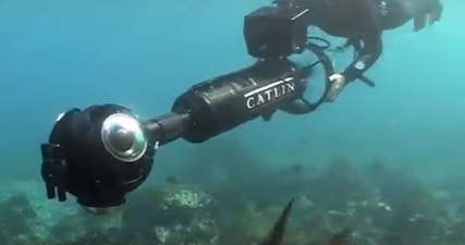
With the help of the Catlin Seaview Survey, Google has added more underwater locations to its “Street View“.
Google put the first marine images up in September 2012, with dives in Australia, the Philippines and Hawaii. Now it covers 16 more countries, including the Galapagos, Monaco, Bermuda and Mexico. It really is a fantastic way to gauge potential dive sites before visiting a country. And it isn’t just for fun. The seaview survey will make ocean change plainly visible for all to see.
For shallow reef surveying – from 0 to 30 m – marine biologists use cameras attached to underwater scooters. Three 360o cameras take pictures from different angles to produce a panoramic seascape. For each image captured, a geo-location and camera direction is also recorded, meaning it’s possible to retake the photograph at a later date from the exact same camera position as the original.
Mapping the Ocean Floor
Marine creatures like manta rays and turtles apparently find it particularly fascinating. The Catlin Seaview team often catch them checking out their own reflection in the wide-angle camera-lens-housing ports.
An underwater tablet has been developed especially for the project, which can connect to the internet and communicate live with the world from underwater.
For dives deeper than 30 m, the survey team sends down under underwater robots. They use data loggers to track changes in water temperature and light level.
The new locations you can now view on Google include Cozumel’s Santa Rosa Wall and Columbia Deep; Monaco’s Larvotto Marine Reserve and Roche Saint Nicholas (featuring the Oceanographic Museum of Monaco); the Cancun Underwater Museum and whale sharks at Isla Contoy in Mexico

